7.1 Jeollabuk-do
Geography of Korea: VII. Jeolla-do> 1. Jeollabuk-do
1. Jeollabuk-do
The province of Jeollabuk-do was created with the splitting of Jeolla-do province into northern and southern portions in 1896. Its provincial seat is Jeonju and its total population is 1.87 million (3.7 percent of the national population), making it the sixth most populous among the country’s nine provinces. Its total land area is 8,066 sq. km., making it the seventh largest province in terms of area, and its population density averages 232.2 persons/sq. km., ranking it the fifth most densely populated of the country’s provinces.
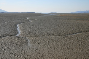
In terms of its geological structure, Jeollabuk-do’s mountainous eastern region is characterized by metamorphic series of rock formations, while in the low-lying western regions are found slightly weathered granite series. The heart of the so-called Honam plains is that lowland area stretching from Gimje to Jeongeup. These plains are largely formed by the basins of the Mangyeong and Dongjin Rivers. These rivers experience heavy tidal influence, but more recently, engineering projects have been building up the rivers’ estuaries to make the rivers more profitable for irrigation while also straightening the river courses. The tidal flats at the river estuaries and adjacent areas have spread extensively. The expansive plains found around Gwanghwal and Okgu are all based on tideland that was reclaimed during the Japanese colonial period.
In the province’s mountainous eastern region are found Mt. Deokyu (1508m) in Muju, which sees much winter snowfall and where a ski resort has been constructed to which one can ski down to from the mountain’s summit, as well as Mt. Naejang (765m) in Jeongeup, which is a popular seasonal destination for its autumnal foliage. Jinan is formed by a level plateau perched at about 400m above sea level. In the center of Jinan towers Mt. Mai (686m), thought to resemble a horse’s ear, while in the area’s villages one readily spots copses of trees that have been planted to conceal what many consider the unsightly appearance of this “horse ear” mountain.
The differences in terrain between the province’s eastern and western portions also translate into climatic variations between the two regions. The western lowlands tend to have higher average temperatures and lesser precipitation than the eastern mountainous region. The mean temperature for Jeonju (in the western area) is -1.2˚C (29.8˚F) for January and 26.3˚C (79.3˚F) for August, while its annual precipitation rate is 1,296mm, slightly higher than the national average. By contrast, in the mountainous eastern region, the mean temperature is -3–4˚C (26.6–39.2˚F) in January and around 24˚C (75.2˚F) in summer, while its annual precipitation averages about 1,354mm. Situated in the coastal area of Gangwon-do’s Taebaeksanmaek Range, this region receives heavy winter snowfalls.
Agriculture in Jeollabuk-do is centered on rice cultivation. In areas such as Gimje, Okgu, and Iksan the ration of land dedicated to paddy field is about 90 percent. As far as dry field agricultural, produce varies by region but includes chili peppers, watermelon, peanuts, radish, cabbage, and ginger, while in Muju and Jinan there is active cultivation of highland vegetables. Although the fishing industry is not too big, the port of Gunsan does serve as a base for some coastal fishing. Although locales like Gyeokpo and Gomso are also important coastal fishing ports, due to the increasing sedimentation of this coast one can say that atrophy is a key feature of the fishing industry here. Until the 1980s, Gomso was renowned for its sea salt and salted fish, though today only the salted fish continues to be produced.
The locus of the province’s industrial development is the Jeonju-Iksan-Gunsan triangle. In terms of output, the light industries such as cosmetics, paper, and tobacco products are more prevalent than the heavy chemical industry. Jeollabuk-do’s manufacturing enterprises as a percentage of total number of companies (2.3%) is the third lowest among provinces, after Gangwon-do (1.4%) and Jeju-do (0.4%), while its manufacturing workers as a percentage of the total workforce (2.9%) is the fourth lowest among the provinces, after Jeollanam-do (2.7%), Gangwon-do (1.2%), and Jeju-do (0.2%). Compare this to the most industrialized province of Gyeonggi-do, where the aforementioned percentages are 33.8 and 30.9, respectively (based on 2011 data).
As of 2014, Jeollabuk-do had 6 designated cities (Jeonju, Gunsan, Gimje, Iksan, Jeongeup, and Namwon) and 8 counties (Wanju, Jinan, Muju, Jangsu, Imsil, Sunchang, Buan, and Gochang). Among these, the most populous is the provincial capital of Jeonju, with 650,000 residents (35 percent of the province’s population), while the least populated is the county of Jangsu, with 23,243 (or 1 percent of the provincial population). Besides Jeonju, the city of Iksan has 307,000 (16 percent of the total) and Gunsan 278,000 (15%), meaning these three cities together account for nearly 70 percent of the province’s population, while the eight counties together making up only a little over 10 percent of the total population of Jeollabuk-do. Among the counties, the most populous is Wanju county with 87,000 people. In Jeollabuk-do, the four counties of Jinan, Muju, Jangsu, and Imsil and the two counties of Gochang and Buan form one electoral district each, while the counties of Wanju and Sunchang form another electoral district. With the incorporation of Jeonju and Namwon as cities, there is no single county in the province that forms its own independent electoral district.
Traditionally, transportation infrastructure in the Jeolla-do has lagged behind other regions, but with the completion of the Seohaean (West Coast) Expressway in 2000 and the expansion of the KTX high-speed rail into the region, the transport situation is gradually improving. Because of the region’s role as the country’s grain basket, railroad lines saw early development here. The Gunsan Line (Gunsan-Iksan) in 1912, the Honam Line (Daejeon-Mokpo) was inaugurated in 1914, and the Jeolla Line (Iksan-Yeosu) in 1936.
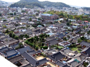
Some representative tourist attractions of Jeollabuk-do include Mt. Naejang, Mt. Seonun, and Mt. Deogyu National Parks, the Jeonju Hanok Village, Mt. Mai in Jinan, and the Muju Ski Resort. At Jeonju’s Hanok Village the visitor may experience aspects of traditional Korean culture, and many of the town’s hanok (a traditional Korean home) have been renovated into motels. Easily accessible in the vicinity of the Hanok Village one can also find many sites of historical interest, including Jeondong Cathedral, Korea’s oldest cathedral, the Gyeonggijeon Shrine enshrining the portrait of King Taejo, founder of the Joseon dynasty, and its nearby hyanggyo (a traditional rural school teaching the Confucian classics), the Jeolla gamyeong (the traditional office complex for the governor of the Jeolla-do region), and the Omokdae historic site (a traditional structure dating back to the early Joseon dynasty and linked to that dynasty’s founder). The city of Jeonju is renowned for its fan craftsmanship and its bibimbap (a traditional Korean dish of mixed rice and vegetables), while its Jeonju International Film Festival (JIFF) is also adding to its fame.

